Addison Bay Fishing Spot
- Last Modified By: vinny60 on 09/12/09 09:25 PM
- Ask about Addison Bay in our Fishing Forums
Photos
Fish Species
Addison Bay Description
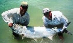
Boating and fishing on and around Marco Island is some of the best in the world. Multiple species of fish pass right by the island on regular migatory routes. The boating is beautiful and calm in the Gulf of Mexico. May through July is generally considered "Tarpon Time, an angler's MUST, as these silver giants pass through the rivers, bays and estuaries.Fish the aqua waters of the Gulf or go to backwater and bays, or the scenic mangrove islands. Try your hand at redfish, snook, grouper, trout, tarpon, permit, snappers or sharks. Whether your an avid fisherman or a novice all waits you here. The islands and bays surrounding Marco were often named for the pioneers living on them such as: Cannon Island, Kice Island and Charity Island, named for Charity Newell Addison. Addison Bay was named for her husband Albert Addison. Johnson Island, Johnson Bay, MacIlvane Island (destroyed when the Isles of Capri developed) and MacIlvane Bay were named for Victor McIlvane and his wife Barbara Frances Collier. Horr's Island was named for John Foley Horr, a U. S. Marshall and pineapple planter on what is now called 'Key Marco.' Curry Island was named for one-armed John Curry who lived there. Big Marco, Little Marco, Key Island now Keywaydin and Tarpon Bay and Unknown Bay are self explanatory while Sugar Bay and Blue Hill Bay make me wonder. Providing entrance to these bays from the Marco River are the passes. The lights and buoys marking the entrances to the passes are: Hurricane Pass, Capri Pass, Big Marco Pass (1889), Caxambas Pass, Coon Key Pass and Goodland Pass.